What is Evapotranspiration?
How irrigation using evapotranspiration improves landscape health, beauty, and sustainability
Just What is Evapotranspiration?
Evapotranspiration, often shortened to ET, is the process of transferring moisture from the earth into the atmosphere. Put simply, evaporation occurs when water vapor leaves the soil or a plant’s surface. Transpiration involves the passage of water through a plant, from its roots through its vascular system. The sum of evaporation and transpiration is evapotranspiration (ET).
ET, which some landscapers refer to as ‘plant sweat,’ has been used by farmers for decades to more efficiently irrigate crops. In recent years, landscapers are adopting ET as a precise way to manage landscape irrigation, as well.
Why is Evapotranspiration Important?
Water continuously moves between the oceans, sky and land. This ongoing circulation is fundamental to the availability of water on the planet and therefore to life on earth. ET is a key process within this cycle, and is responsible for 15% of the atmosphere’s water vapor. Without it, clouds couldn’t form and rain wouldn’t fall.
Why Adopt an Irrigation System Based on ET?
If we can accurately determine how much water has entered and left plants, we can determine how much water landscape needs at any point in time. When plants look unhealthy, the common reaction is to turn on the spigot. But the reality is that most landscapes surrounding our buildings, parks and schools are overwatered.
Overwatering is the cause of the vast majority of issues experienced by plants and trees, particularly disease. By better managing the placement and amount of water used for landscape irrigation, you increase the longevity of plant material and hardscape (retaining walls, wooden fences, masonry). Overwatering also reduces the life span of your asphalt and paved surfaces. It can cause soil consolidation, a leading cause of concrete slab foundation problems and failures. Finally, solutions with automated cycle and soak capabilities reduce runoff because the soil has an opportunity to absorb the water. ET provides an accurate calculation of the amount of water needed for specific weather and a specific set of plants, eliminating waste, and offering direct savings on water and indirect savings on plant and hardscape expenses.
Calculating ET
A number of factors that impact the rate of evapotranspiration, including temperature, wind, solar radiation and relative humidity. Every site has different water needs which can change every day. Using zip codes to define microclimates and set watering schedules, as many irrigation solutions do, will not, therefore, yield good results.
Several methods are used to calculate ET and determine watering needs. The easiest way involves averaging ET values from the two nearest weather stations. The resulting data, however, can be misleading. Microclimates even a few kilometers apart can produce substantially different values. Some property owners and managers purchase their own mini weather stations, but they tend to require frequent calibration and are notoriously unreliable.
The simple and popular Blaney-Criddle method tends to be inaccurate in areas with higher humidity. The Makkink method requires weather station calibration for each specific location. Hargreaves, another common method uses a single sensor. Results can be up to 60% different than other methods, calling their outcomes into serious question.
In an effort to determine the most accurate way to calculate ET and standardize on a single method, the Irrigation Association commissioned an independent study from the American Society of Civil Engineers. After extensive research, it was determined that Penman-Monteith was the winner. Unfortunately, calculations using Penman-Monteith are problematic because it takes numerous factors into account.
How HydroPoint Puts ET Calculations to Work
Valuing accuracy and precision, HydroPoint set out to incorporate Penman-Monteith calculations into its proprietary weather model. With 19.2 million one-square-kilometer grids across the continental U.S. and Canada, however, modeling the equation with four input parameters is exceedingly complicated.
To manage the complexity, HydroPoint uses highly sophisticated forecasting software running on a supercomputer in HydroPoint’s Colorado-based climate center. Every day the climate center downloads:
- 8 million real-time data points via satellite from the National Oceanic and Atmospheric Administration (NOAA)
- Surface observations collected hourly from ground weather stations, ocean buoys and weather balloons around the world
- Global satellite-imaging data every 15 minutes
- Hourly Doppler radar data for the U.S.
In addition, the model uses 256 categories of local ground information such as topography, soil, vegetation and land use. Redundant calculations are made, and the resulting data is inserted into databases using proprietary code.
At a basic level, this means that HydroPoint uses ET to calculate the amount of available water in the soil. So, if it rains, and fills the ground to capacity, the system will determine how long it can wait before it needs to irrigate again. This is based on depletion models that know when the plant will need water, even if the ground looks dry at the surface.
Also, because ground weather readings can be wrong, HydroPoint wrote a heuristic algorithm that crawls through the incoming data day in and day out, wedding out anomalous readings. Data is disqualified, for instance, if there are big swings in temperature or humidity readings from one hour to the next occurring at the same weather station.
To translate ET values into an irrigation schedule usable by a controller, HydroPoint developed scheduling software that factors in ET plus nearly 20 ground parameters entered by the client – from plant and soil type to sprinkler-head model. In addition, HydroPoint analyzes Doppler radar data, and essentially creating an on-off rain switch. The moisture depletion rate is calculated by subtracting the estimated daily ET loss for each square on the grid, thus determining how long the irrigation pause should last—information that is sent to HydroPoint controllers.
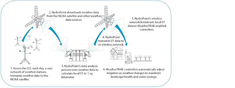
The result is both historical and real-time site-specific weather and accurate ET values to drive irrigation for any location, down to a square kilometer, without the need for weather stations or sensors on site.
The HydroPoint Advantage
HydroPoint, the leader in smart water management, uses ET values to determine the right amount of water for a specific landscape environment. What makes HydroPoint different?
- Highly accurate. HydroPoint ET calculations have been independently proven to be within 2% of an actual onsite weather station.
- Precision results to each specific location. The results are precise to within one square kilometer, ensuring you’re not watering your landscape based on how the watering should occur 3 microclimates away.
- Timely. HydroPoint transmits daily ET data to control irrigation at each individual controller.
- Reliable. By using redundant calculations and relying on numerous data points and weather stations, there is no single point of failure. HydroPoint irrigation systems do not rely on external or add-on devices that could fail, such as weather receivers, soil moisture probes and temperature sensors.
- Centralized control. ET values and local site conditions provided by HydroPoint’s climate center drive irrigation scheduling engines. You get automated, centralized control that can be used from a desktop or on-the-go from a mobile device.
- Easy to deploy and maintenance free. HydroPoint solutions are simple to deploy and require no end-user calibration, keeping your overall cost of ownership low.